
Point of interest.
Friday, February 15th, 2008
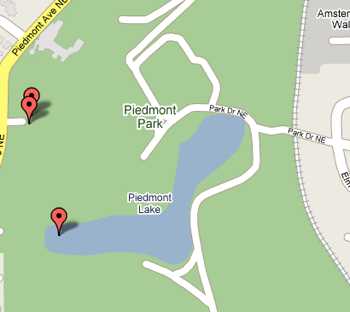
Piedmont Park, according to Tele-Atlas.
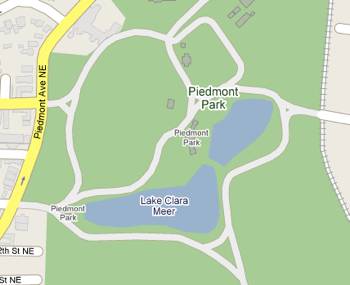
Piedmont Park, according to NAVTEQ.
Well, the more you depend on technology, the more you can be tripped up by the errors in data that technology can seamlessly present to you as “fact.”
You may not know that Google uses more than one set of map data for its various products…Google Earth, their online maps, and the iPhone Google maps application, just to name three.
In order to save money (or something involved in the byzantine licensing structures involved in using map data for purpose ‘A’ versus using it for purpose ‘B’), they provide you with seemingly ‘the same map’—but constructed from data from different providers…and sometimes they don’t agree. Take these two images. The one where the body of water is labeled ‘Lake Clara Meer’ came from NAVTEQ, and the one where it’s labeled ‘Piedmont Lake’ comes from Sanborn Tele-Atlas.
The naming disagreement aside, the images are interesting in how much else is subtly different…the outline of the lake isn’t quite the same…in fact, NAVTEQ depicts it as two separate lakes, and shows a road or pathways all around the lake. Tele-Atlas seems to think those paths stop part of the way around the lake. NAVTEQ thinks the cluster of buildings at the NW corner are not part of the park…Tele-Atlas disagrees. NAVTEQ includes several small buildings inside the park…Tele-Atlas leaves them out but shows you the shopping center (‘Amsterdam Walk’) on the eastern edge (I’ve largely cropped it out, though.) NAVTEQ has a second ‘Piedmont Park’ label on the small cluster of buildings in the center…go figure.
Fortunately for them, I am the ultimate arbiter of all things geographical in our neighborhood, and I have my verdict.
And (ripping envelope open), the winners are:
- The name of the lake is, of course, Lake Clara Meer. (Sammy and I walk around it all the time.)
- The lake is actually one body of water, with a pedestrian bridge across it where NAVTEQ shows a break.
- The buildings on the NW corner are those of the Piedmont Driving Club (a snooty private club), and are indeed outside the park.
- The pathways are much more as NAVTEQ depicts them but don’t try to drive on them.
(By the way, ditch the plain ol’ map completely and take a look at Google’s very high-res airphoto/satellite imagery they have of the park to see all of this in excruciating detail.)
The good news here is that you can at least do good for your fellow navigatees by reporting these errors. The trick, of course, is to get the correct info to the correct data provider. Just complaining to Google doesn’t, in general, help. If the data copyright (in tiny type at the bottom of your map) says “NAVTEQ”, then you can report the errors here. For Tele-Atlas (the copyright says these days ‘Sanborn Tele-Atlas’), use this website.
Semi-amusingly, both sites have verbiage that implies that their data sets started out absolutely perfect to begin with, and it’s just the sturm and drang of our changing world that necessitates having a place where corrections can be made (“In our changing physical world, where a significant percentage of roadways are altered every year, the Tele Atlas database must undergo continual enhancements to reflect factors ranging from navigational changes caused by construction projects to the creation of roads in new housing developments…”) Well, some stuff comes and goes, but Lake Clara Meer has been there for a century or so…and last I checked, it still is.
